April is a cold time to sail. I should clarify: this April has been a cold time to sail. We've seen more snow from the cockpit on this cruise than on any of our winter ones, with the most recent flurry just a few days ago. Most nights have fallen below freezing.
De Novo doesn't have a diesel generator or big battery bank. We've always relied on our array of solar panels and the rare boost from our engine alternator to keep our batteries charged. And in the past, this has been enough, even in summer in Alaska. But we've relied on our forced air heating system more on this trip than others. Its electrical draw has been challenging at anchor, especially on days with a lack of sunlight to power our panels. This means allocating heater use and often sacrificing comfort for precious battery hours.
So you can imagine our frustration when, on a frosty morning in Porteau Cove with full cloud cover, we turned on our engine and our alternator stopped working. We found it wasn't a simple fix like tightening the belt or switching it out, so we decided to get a professional opinion (and shore power) in Gibsons. Apparently, an old electrical connection had finally failed after years of just barely holding on. By replacing the old spade connector with a more sealable butt connector and installing our spare alternator, we could move on and enjoy the rest of the trip. We tested our original alternator days later at a shop in Powell River, but the results about the internal regulator were questionable. After some online discussion about whether we should trust internal vs external regulators (or both), we decided to simply buy a new spare and move on.
Bottom line: it's cold! Like see-your-breath-inside-the-cabin cold.
So, why do we enjoy the shoulder season so much? Because it's inarguably, undoubtedly worth it. There's more wind for sailing. The anchorages and trails are empty, even in Desolation Sound. It's quiet. And without the crowds, the wildlife is more abundant. Strangely, the cold adds another layer of subtle beauty to the BC coast. And the warm days feel more like gifts than expectations.
Don't get me wrong: we're ready for warmer weather. But we're acclimating and even enjoying the shoulder season for what it is now.
Our path since we last posted:
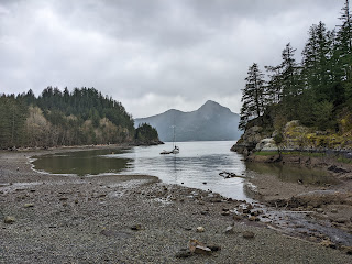 |
| Xwáw̓chayay/ Porteau Cove. On the chart, the floating dock appears to be in one fathom of water. That's wrong. We went in on high tide to take a sounding and found ourselves in nearly 60 feet of water. So deep-drafted boats shouldn't have a problem getting to the dock. Note: Anchoring is forbidden in the bay. The two white, small buoys are shoreline markers and dry at low tide; do not tie to them. |
 |
| Cailin, Anthony, and Pumpkin came to meet us in Porteau Cove. Thank you for braving the cold, you three! Here's Cailin and Pumpkin getting settled in to their campsite. Also, I love Pumpkin. |
 |
| We survived a rough overnight storm in Gibsons outside of the breakwater, but this boat wasn't so lucky. :/ |
 |
| Plumper Cove on Keats, usually a busy anchorage and dock, completely empty in the shoulder season |
 |
| Nurse logs and shags provide new growth throughout the PNW |
 |
| The viewpoint at Keats. Tip: the new trail map posted at Plumper Cove doesn't show the old trails, including the ones to the peaks. The old trail map is on a laminated sheet, tucked behind the board of the new map. Shh! |
 |
| Okay, we promise we'll start using a camera with a zoom lens! :) |
 |
Heading into Smuggler Cove for the first time.
While the tight entrance (middle of picture, slight left) is safe with good charts, I still held my breath. |
 |
Smuggler Cove requires a stern tie to avoid swinging into shallow areas
(and other boats in the summer) |
 |
| Smuggler Cove was named after an American civil war confederate soldier turned pirate who smuggled Chinese laborers from this area into the United States. He would hide in these rocky inlets because so few officials knew of them. He exploited his passengers' desperation and even tied them to pig iron and drowned them any time he feared he'd get caught. It's a horrific story for such a beautiful place. |
 |
| Smuggler Cove Rorschach test |
 |
| All the little nooks to explore by trail and kayak |
 |
| BC Parks renovated the boardwalk trail this winter, finishing it the day we arrived. It looks great! |
 |
| Smooth, happy sailing to Jedidiah Island |
 |
The coves along Jedidiah are tiny and require careful navigation and stern tying, as seen here.
However, we didn't stay long. When winds barreled in later that evening, we decided to weigh anchor and head to Boho Bay on Lasqueti Island, just a mile west, and return by kayak the next day. We recommended Boho in a northwesterly: while seas built outside overnight, Boho stayed mirror calm. |
 |
| So much driftwood on Jedidiah! |
 |
| View from Mt. Gibraltar on Jedidiah |
 |
| Homesteaders raised sheep and goats on Jedidiah since the 1890s. The last residents here, the Palmer family, moved away several decades ago and sold their land to BC Parks in the 1990s. Their homestead and orchard still stand, and several generations of feral sheep and goat now run the 600 acre (243 hectares) island. |
 |
| Their main house is a gated time capsule |
 |
Did we mention sheep?!
Human season doesn't usually start this early, so we think we surprised them. |
 |
Oh my goodness! Hello you!
A lively downwind sail up Strait of Georgia |
 |
Lots of room to stretch in Tenedos Bay, Desolation Sound
|
 |
| Unwin Trail |
 |
Winter storms fell countless trees on the trail, and traversing the thickets proved an adventure.
|
 |
| We can do it! |
 |
| The hike from Tenedos Bay ends at Prideaux Haven. It's a popular anchorage in the summer, where several dozen boats raft, stern tie, and swing dangerously close to one another. This time, we counted one boat. One. |
 |
| Another empty and delightful anchorage: Cochrane Bay down Malaspina Inlet, our gateway to the Sunshine Coast Trail, a 180 km path of wonderland |
 |
| Adorable and lifesaving shelters along the Sunshine Coast Trail [SCT] |
 |
| More adorableness on the SCT |
 |
Copeland Islands
 |
 |
| Exploring the east side of Thulin Passage |
 |
| Klah-Ah-Men, Tla'amin name meaning "Our People," also known as Lund. The Tla'amin Nation runs the resort, fuel dock, and other businesses in town. We're enjoying it here. |
 |
| Lund is one end of Hwy 101 which runs all the way to Castro, Chile. |
 |
| On the steps leading to the Klah-Ah-Men building: "There are those for whom travel is soul food, as necessary to life as clean, beautiful air and water." We couldn't agree more. |


.jpg)


Fantastic journeying. Thanks for the great pics. Take care!
ReplyDeleteLove it! Love the pics. You keep these posts coming, D! I love hearing about what you both are up to! -Laura
ReplyDeleteThank you, Laura! ❤️❤️
DeleteOh my goodness…. I typed up a real nice comment with all the place names I found for y’all and then when I left the tab for too long I lost it all. I’m gonna leave my links here for later, because now I’m too tired to go back and look through them again 😅
ReplyDeletesuper freaking cool Tla’amin place name project: https://powellriver.ca/pages/photo-history-of-powell-river
Highlight reel of the above (nb—I think the name given for Desolation Sound etc. are a placeholder for lost names rather than all the same name): https://www.powellrivermuseum.ca/place-names.html
she shashishalhem (shíshálh Language) resources including restored community names: https://shishalh.com/culture-language/sechelt-language/
Restored park names in she shashishalhem: https://www.scrd.ca/files/File/Community/Parks/2019%20Oct%20SCRD%20shashishalhem%20park%20names.pdf
Skwxwú7mesh Úxwumixw (Squamish Territory) place names: http://squamishatlas.com/
But I’ll come back and update with a list soon :)
DeleteWhat a great resource! Thanks, Callie!
DeleteI am way behind on my reading…beautiful post! Love the last picture and quote!!
ReplyDelete